 Geobru catalogue
2020
Type of resources
Available actions
Topics
INSPIRE themes
Keywords
Contact for the resource
Provided by
Years
Formats
Representation types
Update frequencies
status
Service types
Scale
Resolution
-
Study to analyse all available data on school mobility and draw conclusions on the functioning of School Travel Plans: what works well, what could be improved? The study produced interesting data analyses and useful recommendations that have since been put into practice.
-

This dataset contains the latest version of the borders of the Belgian postal codes, including the "special" postal codes (0612, 1049, 6099,…).
-
The study consists of interviews (in depth semi-structured) with 12 project leaders of the call 'Brussels on Holiday' 2020. The objective was to be able to (re)orient the future call for projects.
-

Administrative units - current situation corresponds to the dataset of administrative units from the reference database for the land register data. Administrative limits are legally defined by an administrative entity or between two administrative entities. In Belgium, administrative limits as legally defined are fixed and can only be changed by a law, ordinance or decree. The General Administration of Patrimonial Documentation of the FPS Finance is named by the federal authorities as the authentic source of Belgian administrative limits. This dataset corresponds to the current situation at the time of consultation. It is composed of five geometric classes. The first class corresponds to the whole national territory. The second corresponds to the territory of the three regions, the third to the territory of the provinces, the fourth to the territory of the administrative districts, the fifth to the territory of the municipalities. The dataset is freely downloadable via the ad hoc WFS service.
-

Land register plan - current situation corresponds to the dataset of land register from the reference database for the land register data CadGIS. The land register plan is one of the elements that make up the patrimonial documentation. It is defined as “the graphic representation and assembling on a plan of all the cadastral plan parcels of the Belgian territory”. A plan parcel, such as defined in Article 2 of the Royal Decree of 30 July 2018, is a part of Belgian territory, geographically delimited and identified by the General Administration of Patrimonial Documentation on the land register plan, which corresponds to the ground surface area of one or more patrimonial cadastral parcel(s) (real estate property as mentioned in Article 472 of the 1992 Income Tax Code in respect of which the cadastral income is fixed). This dataset corresponds to the current situation at the time of consultation. It is composed of fourteen geometric layers. The first five are the administrative units, namely the country, the regions, the provinces, the districts and the municipalities. The sixth and seventh layers correspond to the cadastral units, divisions and sections. the eighth layer includes the cadastral blocks, the ninth, the property stones, the tenth, the addresses, the eleventh, the polders and wateringues, the twelfth, the cadastral plan parcels, the thirteenth the buildings managed by the AGDP, and the fourteenth, buildings managed by the regions. The dataset is freely downloadable via the ad hoc WFS.
-
Following a request from the Brussels Regional Government and within the framework of the BKP, an additional study was carried out in 2020 to investigate the possibility of lowering and greening the canal banks. This would strengthen the link between public space, water and nature. The objective of this feasibility study was to: -identify the land on the canal that could be transformed into quality public spaces ; -evaluate the technical and spatial constraints to investigate the possibilities of greening the banks, both on the banks themselves and on the waterway.
-
School contract is a regional program for urban renewal. It aims to upgrade school neighbourhoods in Brussels and strengthen the relationship between schools and their surroundings.
-

Brussels-Capital Region : This map shows the Health Impact Screening score for air quality (0-8) in the Brussels Capital Region. It was produced as part of the 2020 study on the "Impact of 'Nature-Based Solutions' (NBS) on urban residents' exposure to air pollution, noise pollution or high temperatures - Overview of general knowledge and recommendations for the Brussels-Capital Region". This map is based on the 2018 annual average nitrogen dioxide concentration map. For the methodology used, see p.49. The study report (in dutch) is available at http://document.environnement.brussels/opac_css/elecfile/NatureBasedSolutions
-
Brussels-Capital Region : location of the different surface water quality monitoring sites under the Water Framework Ordonnance and Directive. Surface waters concerned are surface water bodies: Canal, Senne and Woluwe. Monitoring involves a series of chemical, physico-chemical parameters... The code and the name of the monitoring site are given.
-
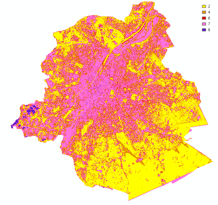
Brussels-Capital Region : This map shows the Health Impact Screening score for heat stress (0-8) in the Brussels Capital Region. It was produced as part of the 2020 study on the "Impact of 'Nature-Based Solutions' (NBS) on urban residents' exposure to air pollution, noise pollution or high temperatures - Overview of general knowledge and recommendations for the Brussels-Capital Region". This map is based on the maximum Wet Bulb Globe Temperature (WBGT) map of 24 August 2016. For the methodology used, see p.48. The study report (in dutch) is available at http://document.environnement.brussels/opac_css/elecfile/NatureBasedSolutions