 Geobru catalogue
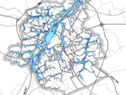
Hydrography
Type of resources
Available actions
Topics
INSPIRE themes
Keywords
Contact for the resource
Provided by
Years
Formats
Representation types
Update frequencies
status
Service types
Scale
-
Brussels-Capital Region: This service is the service mapping data visualization of the dataset Hydrography of Brussels Environment (compliant with the data specifications of INSPIRE) including the watercourse network, drainage basin and surface waters of the Brussels-Capital Region.
-
This dataset corresponds to the flood hazard maps for the Brussels-Capital Region, in accordance with Directive 2007/60/EC of the European Parliament and of the Council of 23 October 2007 on the assessment and management of flood risks. It is made of16 geometric classes. These flood hazard maps show the areas that may be flooded by watercourses (fluvial flooding), as a result of rainwater runoff during heavy rainfall (pluvial flooding), or by sewer overflow at the surface onto public roads (the latter are not fully available for the region). And underground flooding resulting from a groundwater table close to the surface. These maps show the extent, water levels and flow velocities of the areas that will be flooded under various scenarios: a return period of 25, 100 and 100 years, and a climate change scenario (corresponding to a hundred-year rainfall event from 2100 onwards, based on a climate warming trajectory of up to +3.5 °C). Please note that these maps have no regulatory value.
-
Brussels-Capital Region : This flood hazard map identifies areas where flooding could occur due to stream overflow, runoff from rainwater, overflowing sewers or a temporary rise in the water table, even in places where no flooding has been observed until now. The absence of a flood hazard zone on the map does not guarantee that flooding will never occur as it does not take into account certain causes of flooding such as a local failure of the sewage network, etc. Please note that these maps have no regulatory value, they have been produced in accordance with the European Directive 2007/60/EC to determine the prevention and protection measures. The maximum scale is 1/10.000 as the modelled data are not representative on a larger scale.
-
This service allows you to download Brussels Environment datasets relating to the theme ‘Hydrography’, in accordance with the technical specifications of the INSPIRE directive.
-

Brussels-Capital Region : watercrouses in Brussels Region, defined under the Directive and the Ordinance Water
-
This dataset corresponds to the atlas of the hydrographic network of the Brussels-Capital Region, in accordance with the Decree of 23 May 2024 classifying non-navigable watercourses, designating regional ponds, determining the content, scope, procedures and deadlines for drawing up the Atlas of the hydrographic network of the Brussels-Capital Region and adopting this Atlas. It is made of ten geometric classes: classified watercourses, unclassified watercourses, bank crests, regional ponds, ditches, engineering structures, sluice walls, watercourse points of origin, cross profiles, embankments.
-
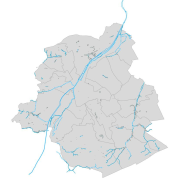
This dataset corresponds to hydrography in the Brussels-Capital Region. It is made up of nine geometric classes: drainage basins, arched watercourses, open watercourses, surface water (ponds, marshes, swamps), surface water bodies, springs, right-of-way zone for arched watercourses, non aedificandi zone.
-
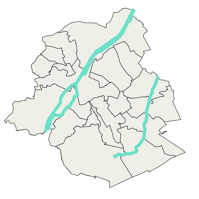
Brussels-Capital Region : watercrouse links in Brussels Region, defined under the Directive and the Ordinance Water
-

Land register plan - current situation corresponds to the dataset of land register from the reference database for the land register data CadGIS. The land register plan is one of the elements that make up the patrimonial documentation. It is defined as “the graphic representation and assembling on a plan of all the cadastral plan parcels of the Belgian territory”. A plan parcel, such as defined in Article 2 of the Royal Decree of 30 July 2018, is a part of Belgian territory, geographically delimited and identified by the General Administration of Patrimonial Documentation on the land register plan, which corresponds to the ground surface area of one or more patrimonial cadastral parcel(s) (real estate property as mentioned in Article 472 of the 1992 Income Tax Code in respect of which the cadastral income is fixed). This dataset corresponds to the current situation at the time of consultation. It is composed of fourteen geometric layers. The first five are the administrative units, namely the country, the regions, the provinces, the districts and the municipalities. The sixth and seventh layers correspond to the cadastral units, divisions and sections. the eighth layer includes the cadastral blocks, the ninth, the property stones, the tenth, the addresses, the eleventh, the polders and wateringues, the twelfth, the cadastral plan parcels, the thirteenth the buildings managed by the AGDP, and the fourteenth, buildings managed by the regions. The dataset is freely downloadable via the ad hoc WFS.
-
Land register plan - situation on January 1st corresponds to the dataset of land register from the reference database for the land register data CadGIS. The land register plan is one of the elements that make up the patrimonial documentation. It is defined as “the graphic representation and assembling on a plan of all the cadastral plan parcels of the Belgian territory”. A plan parcel, such as defined in Article 2 of the Royal Decree of 30 July 2018, is a part of Belgian territory, geographically delimited and identified by the General Administration of Patrimonial Documentation on the land register plan, which corresponds to the ground surface area of one or more patrimonial cadastral parcel(s) (real estate property as mentioned in Article 472 of the 1992 Income Tax Code in respect of which the cadastral income is fixed). This dataset corresponds to the legal situation as defined on 1 January of the reference year. It is composed of thirteen geometric classes and one class without geometry. The first class includes the cadastral plan parcels present in the corresponding administrative unit. The second class includes the buildings managed by the General Administration of Patrimonial Documentation, the third class includes the buildings managed by the regions, the fourth class includes equipment and tools, the fifth class includes water bodies, the sixth class includes cadastral blocks, the seventh, easements and paths, the eighth, toponymic lines, the ninth, toponymic points, the tenth, property boundaries, the eleventh, parcel numbers, the twelfth, cadastral divisions, and finally, the thirteenth, cadastral limits. The class without geometry corresponds to the table of tax situations. The dataset can be freely downloaded as a zipped shapefiles.