 Geobru catalogue
2017
Type of resources
Available actions
Topics
INSPIRE themes
Keywords
Contact for the resource
Provided by
Years
Formats
Representation types
Update frequencies
status
Service types
Scale
Resolution
-

This web service provides the display of the datasets Administrative units - current situation and Land register plan - current situation. This webservice does not comply with the INSPIRE specifications, and the datasets to which it gives access do not comply with the INSPIRE specifications. This web service is available in several formats. It is recommended to use the PNG format.
-
This web service provides the download per object of the datasets Administrative units - current situation and Land register plan - current situation. This webservice does not comply with the INSPIRE specifications, and the datasets to which it gives access do not comply with the INSPIRE specifications.
-
This WMS service allows to display Brussels Environment datasets that comply with INSPIRE data specifications relating to INSPIRE theme 'Landcover'.
-

This dataset includes the RGB (Red, Green, Blue) orthophotos created in 2017. The images cover the entire Brussels Capital Region, with a resolution of 5 centimeters.
-
Web Map Service for layers of Brussels Mobility
-

Brussels-Capital Region : Railway traffic noise register for the reference year 2021 (noise contours maps) for the Lden acoustic indicator (day-evening-night noise indicator). These maps are produced with an acoustic model in accordance with the prescriptions of the European directive 2002/49/EC.
-

Brussels-Capital Region : Air traffic noise map for the reference year 2021 (noise contours maps) for the Lden acoustic indicator (day-evening-night noise indicator). These maps are produced with an acoustic model in accordance with the prescriptions of the European directive 2002/49/EC
-

Brussels-Capital Region : Road traffic noise register for the reference year 2021 (noise contours maps) for the Ln acoustic indicator (night-time noise indicator). These maps are produced with an acoustic model in accordance with the prescriptions of the European directive 2002/49/EC.
-

Brussels-Capital Region : Road traffic noise register for the reference year 2021 (noise contours maps) for the Lden acoustic indicator (day-evening-night noise indicator). These maps are produced with an acoustic model in accordance with the prescriptions of the European directive 2002/49/EC.
-
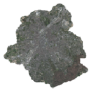
This dataset includes the RGB (Red, Green, Blue) orthophotos created in 2017. The images cover the entire Brussels Capital Region, with a resolution of 5 centimeters.