 Geobru catalogue
INSPIRE - Orthophoto2017
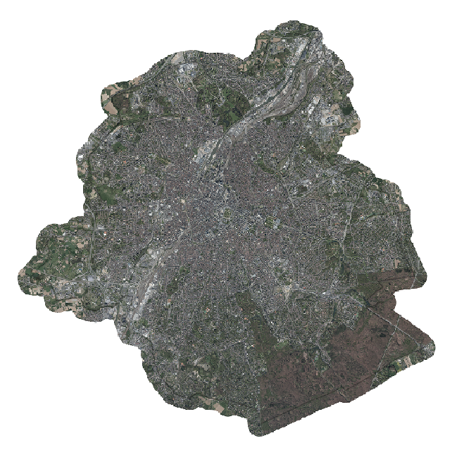
This dataset includes the RGB (Red, Green, Blue) orthophotos created in 2017. The images cover the entire Brussels Capital Region, with a resolution of 5 centimeters.
Simple
- Date (Creation)
- 2017-04-20T17:00:00
- Date (Revision)
- 2017-07-17T17:00:00
- Date (Publication)
- 2017-07-17T17:00:00
- Identifier
- BE.CIRB / INSPIRE_URBIS_ORTHO2017_RBC
Point of contact
Paradigm
https://be.brussels/en/about-region/structure-and-organisations/administrations-and-institutions-region/paradigm
https://be.brussels/en/about-region/structure-and-organisations/administrations-and-institutions-region/paradigm
- Maintenance and update frequency
- As needed
- GEMET - INSPIRE themes, version 1.0
-
- Orthoimagery
- GeoBru Administrative Regions
-
- Brussels
- Région de Bruxelles-Capitale
- Belgium
- GeoBru brussels keywords
-
- Layers
- Reporting Inspire
- Spatial scope
-
- Regional
- INSPIRE feature concept dictionary
-
- Orthoimage Coverage
- Access constraints
- Other restrictions
- Other constraints
- No limitations to public access
- Use constraints
- Other restrictions
- Other constraints
- Creative Commons Attribution (CC-BY) - required citation of data source. The full license is available here: https://creativecommons.org/licenses/by/4.0/legalcode
- Spatial representation type
- Grid
- Distance
- 40 cm
- Metadata language
- Français
- Metadata language
- Nederlands; Vlaams
- Topic category
-
- Imagery base maps earth cover
N
S
E
W
))
- gml32:beginPosition
- 2017-07-17T00:00:00
- gml32:endPosition
- 2017-07-17T00:00:00
- Unique resource identifier
- EPSG:3035
- Geometric object type
- Complex
- Geometric object count
- 1
- Distribution format
-
-
GML
()
-
GML
()
- OnLine resource
- Ortho2017 ( OGC Web Map Service )
- OnLine resource
-
View service – UrbIS raster
(
OGC Web Map Service
)
View service – UrbIS raster
- OnLine resource
-
Download service - UrbIS raster
(
OGC Web Feature Service
)
Download service - UrbIS raster
- OnLine resource
- Units of distribution
- MB
- Transfer size
- 0.5
- OnLine resource
- UrbOrthoY17_RBC_40cm.zip ( WWW:DOWNLOAD-1.0-http--download )
- Units of distribution
- MB
- Transfer size
- 0.5
- Hierarchy level
- Series
Conformance result
- Date (Publication)
- 2010-12-08
- Explanation
- The dataset does fullfill the minimal requirements
- Pass
- Yes
- Statement
- The data collection flight took place in the Brussels Capital Region on an East-West axis on 20 April 2017. The images were taken using an UltraCam Eagle Mark3 camera with a 210 mm focal length and a three-channel sensor. R, G, B (Red, Green, Blue). An orthorectification process eliminates distortions caused by relief and perspective, allowing UrbIS vector layers to be superimposed on orthophotos or measurements to be made directly on the images.
- File identifier
- 62e646e7-6101-4f79-b414-53c3e1b1ed8c XML
- Metadata language
- Français
- Parent identifier
- Orthophoto - 2016 db2e0ac3-a8ac-464b-bfef-514dfa37d4e6
- Hierarchy level
- Dataset
- Date stamp
- 2025-12-09T17:24:07
- Metadata standard name
- ISO19115
- Metadata standard version
- 2003/Cor.1:2006
Overviews
large_thumbnail
thumbnail
Spatial extent
N
S
E
W
Provided by

Associated resources
Not available