 Geobru catalogue
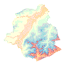
Elevation
Type of resources
Available actions
Topics
INSPIRE themes
Keywords
Contact for the resource
Provided by
Years
Formats
Representation types
Update frequencies
status
Service types
Scale
Resolution
-

The Digital terrain model product is a raster image composed of pixels whose value corresponds to altitude. The dataset is freely downloadable as a zipped file.
-
The UrbIS - Digital surface model product is a raster image capturing all the objects (natural or built) on the surface of the ground. The dataset is freely downloadable as a zipped file.
-
The product Airborne LiDAR (Light Detection and Ranging) pountcloud provides a three-dimensional vector model covering the Brussels-Capital region. This is the product of several LiDAR data collection campaigns captured from the air. The data is available in open data, via a visualization tool and direct download as a Las file.
-
The UrbIS - Landscape product (formerly UrbIS - ADM 3D V2 Beta) is a dataset that combines the data from the “3D Constructions” product with the “Digital terrain model” to display a three-dimensional model of the ground and buildings in the Brussels-Capital region. The dataset is freely downloadable as zipped files.
-

The "UrbIS - Contour lines" product represents the elevation of the Brussels region by means of contour lines with intervals of 0.5 metres. The dataset is freely downloadable as a zipped file.
-
The 2012 Triangulated irregular network (TIN) product is a mesh composed of irregular triangles. The dataset is freely downloadable as a zipped file.
-
This map corresponds to the "Carte topographique et hypsométrique de Bruxelles et ses environs", drawn around 1858 at a scale of 1:20,000 by Joseph Huvenne (draftsman, topographer) and engraved by J. Ongers. It covers the Brussels region from Neder-Over-Heembeek to Drogenbos and from Berchem-Sainte-Agathe to Auderghem.
-
Brussels-Capital Region: Contour lines give an overview of the real ground on a topographic map. A contour line is the intersection of real terrain with a horizontal plane of given elevation. Contour lines are obtained from the Digital Terrain Model (DTM).
-
This view service allows, via a formatted URL, to display all the INSPIRE vector datasets managed by Paradigm in the Brussels-Capital Region.
-
This discovery service allows, by means of a formatted URL, to access the metadata covered by the INSPIRE Directive, in accordance with Implementing Decision 2019/1372.