 Geobru catalogue
geoscientificInformation
Type of resources
Available actions
Topics
INSPIRE themes
Keywords
Contact for the resource
Provided by
Formats
Representation types
Update frequencies
status
Scale
-
Brussels-Capital Region: map of areas likely to be flooded (future events). Prepared in accordance with Article 4 of the European Flood Directive 2007/60/EC.
-
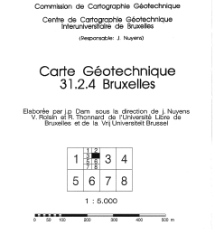
Brussels-Capital Region: The geotechnical maps of Brussels were elaborated by J.P. Dam, under the direction of prof. J. Nuyens, V. Roisin and R. Thonnard of the Université Libre de Bruxelles (ULB) and of the Vrije Universiteit Brussel (VUB), members of the Centre Interuniversitaire pour la Cartographie Géotechnique directed by J. Nuyens (ULB). They were then published at a scale of 1/5000 between 1976 and 1990 by the ‘Institut Géotechnique de l’Etat’ (State Geotechnical Institute). The constituent documents (maps and associated reports) provide an overview of the following points: - tests carried out in the region ; - depth of the water table ; - nature and position of the tertiary substratum ; - nature and strength of the various surface layers; - units with a specific overlay of the formations encountered. Their initial objective was to respond to the needs of the builders for synthetic and easily accessible documentation relating to the subsoil of the Brussels region. The plates and documents provided did not claim absolute precision because of the interpolations and extrapolations necessary for their establishment. The present archive is presented in three forms: - Digitized maps and associated FR/NL explanatory notes .pdf ; - Georeferenced 'raster' maps (lambert 72); - Vector' maps (lambert 72). List of available maps: 31.2.4; 31.2.6; 31.2.8; 31.3.1; 31.3.2; 31.3.3; 31.3.4; 31.3.5; 31.3.6; 31.3.7; 31.3.8; 31.4.7; 31.7.1; 31.7.2; 31.7.3.
-
Brussels-Capital Region: Map of the areas affected by historical flooding (past events). Prepared in accordance with Article 4 of the European Flood Directive 2007/60/EC.
-
This dataset corresponds to geothermal installations in the Brussels-Capital Region. It is made of one geometric class.
-
Brussels-Capital Region : data on the 5 Groundwaterbody of the Area of Brussels, defined under the Directive and the Ordinance Water : code European, code of Brussels and name of the water mass, hydrographic district
-

This dataset corresponds to the piezometry of the phreatic system in the Brussels-Capital Region. It is made of four geometric classes: piezometric levels in the Brussels phreatic system, phreatic level heights, phreatic level depths, and phreatic level depths (HD).
-

This dataset corresponds to the groundwaterbodies in the Brussels-Capital Region, in accordance with Directive 2000/60/EC of the European Parliament and of the Council of 23 October 2000 establishing a framework for Community action in the field of water policy (Water Framework Directive). It is made up of one geometric class: groundwaterbodies.
-
Brussels-Capital Region: Map indicating the entire Brussels-Capital Region for which a potentially significant flood risk exists or can be expected in the future. Prepared in accordance with Article 5 of the European Flood Directive 2007/60/EC.
-
This dataset corresponds to the stratigraphic units in the Brussels-Capital Region. It is made of four geometric classes: geological field data, extensions of stratigraphic units, geological map of the Brussels Region, elevations of the tops of the stratigraphic units, and thicknesses of the stratigraphic units.
-
Brussels-Capital Region : spatial extents of the stratigraphic units (SU/BCR), SU/BCR_011 Backfill and SU/BCR_12 Silts cover excepted. This data is limited to the Brussels-Capital Region’s border extended with a 500 m buffer zone. The hydrogeological unit (HU/BCR) of each SU/BRC is indicated in the attribute data. These spatial extents were extracted from the BruStrati3D v1.1 geological model, except for the extensions of the quaternary units which were extracted from the Databank Ondergrond Vlaanderen database. This data is generated from models and may contain errors, inaccuracies and gaps. It has informative value and may under no circumstances replace a study carried out by an expert. Bruxelles Environnement cannot be held liable for the consequences of the use of this information.