 Geobru catalogue
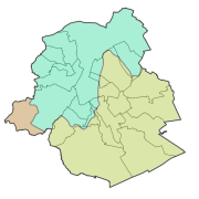
flooding
Type of resources
Available actions
Topics
INSPIRE themes
Keywords
Contact for the resource
Provided by
Formats
Representation types
Update frequencies
Scale
-
Brussels-Capital Region: Map of the areas affected by historical flooding (past events). Prepared in accordance with Article 4 of the European Flood Directive 2007/60/EC.
-
Brussels-Capital Region: Map indicating the entire Brussels-Capital Region for which a potentially significant flood risk exists or can be expected in the future. Prepared in accordance with Article 5 of the European Flood Directive 2007/60/EC.
-
Brussels-Capital Region: map of areas likely to be flooded (future events). Prepared in accordance with Article 4 of the European Flood Directive 2007/60/EC.
-
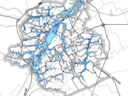
Brussels-Capital Region : This flood hazard map identifies areas where flooding could occur due to stream overflow, runoff from rainwater, overflowing sewers or a temporary rise in the water table, even in places where no flooding has been observed until now. The absence of a flood hazard zone on the map does not guarantee that flooding will never occur as it does not take into account certain causes of flooding such as a local failure of the sewage network, etc. Please note that these maps have no regulatory value, they have been produced in accordance with the European Directive 2007/60/EC to determine the prevention and protection measures. The maximum scale is 1/10.000 as the modelled data are not representative on a larger scale.
-
Brussels-Capital Region :
-
This dataset corresponds to the flood hazard maps for the Brussels-Capital Region, in accordance with Directive 2007/60/EC of the European Parliament and of the Council of 23 October 2007 on the assessment and management of flood risks. It is made of16 geometric classes. These flood hazard maps show the areas that may be flooded by watercourses (fluvial flooding), as a result of rainwater runoff during heavy rainfall (pluvial flooding), or by sewer overflow at the surface onto public roads (the latter are not fully available for the region). And underground flooding resulting from a groundwater table close to the surface. These maps show the extent, water levels and flow velocities of the areas that will be flooded under various scenarios: a return period of 25, 100 and 100 years, and a climate change scenario (corresponding to a hundred-year rainfall event from 2100 onwards, based on a climate warming trajectory of up to +3.5 °C). Please note that these maps have no regulatory value.
-

Brussels-Capital Region : This map depicts elements exposed to potential flooding.
-

Brussels-Capital Region: Map of the areas affected by historical flooding (past events). Prepared in accordance with Article 4 of the European Flood Directive 2007/60/EC.
-

Brussels-Capital Region : location of the different surface water quality monitoring sites under the Water Framework Ordonnance and Directive. Surface waters concerned are surface water bodies: Canal, Senne and Woluwe. Monitoring involves a series of chemical, physico-chemical parameters... The code and the name of the monitoring site are given.