 Geobru catalogue
Keyword
Elevation
Type of resources
Available actions
Topics
INSPIRE themes
Keywords
Contact for the resource
Provided by
Years
Formats
Representation types
Update frequencies
Service types
Scale
From
1
-
3
/
3
-
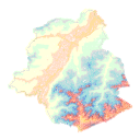
Brussels-Capital Region: Contour lines give an overview of the real ground on a topographic map. A contour line is the intersection of real terrain with a horizontal plane of given elevation. Contour lines are obtained from the Digital Terrain Model (DTM).
-
This view service allows, via a formatted URL, to display all the INSPIRE vector datasets managed by Paradigm in the Brussels-Capital Region.
-
This discovery service allows, by means of a formatted URL, to access the metadata covered by the INSPIRE Directive, in accordance with Implementing Decision 2019/1372.