 Geobru catalogue
INSPIRE – Modèle numérique de terrain
INSPIRE - Digitaal terreinmodel
INSPIRE - Digital Terrain Model
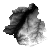
Le Modèle Numérique de Terrain (DTM) décrit la forme tridimensionnelle de celle de la surface de la Terre (topographie de la surface du sol). Le Modèle Numérique de Terrain (DTM) est disponible dans trois représentations différentes :
- Elevation - Éléments vectoriels ;
- Elevation - Grid ;
- Elevation – TIN.
De Digital Terrain Model (DTM) beschrijft de driedimensionale vorm van het oppervlak van de Aarde (topografie van het oppervlak).
De Digital Terrain Model (DTM) is verkrijgbaar in drie verschillende voorstellingen:
- Elevation - vector elementen;
- Elevation - Grid;
- Elevation - TIN.
The Digital Terrain Model (DTM) describes the three-dimensional shape of the surface of the Earth (topography of the surface).
The Digital Terrain Model (DTM) is available in three different representations:
- Elevation - vector elements;
- Elevation - Grid;
- Elevation - TIN.
Simple
-
Datum (creatie)Date (Creation)Date (Création)
- 2012-03-30T17:00:00
-
Datum (publicatie)Date (Publication)Date (Publication)
- 2012-12-21T17:00:00
-
IdentifierIdentifierIdentificateur
- BE.CIRB / BRU_URBIS_DTM
https://paradigm.brussels/fr?set_language=fr
-
HerzieningsfrequentieMaintenance and update frequencyFréquence de mise à jour
-
niet geplandNot plannedNon planifiée
-
GEMET - INSPIRE themes, version 1.0
-
-
AltitudeHoogteElevation
-
-
GeoBru Administrative Regions
-
-
BelgiqueBelgiëBelgium
-
Région de Bruxelles-CapitaleBrussels Hoofdstedelijk GewestRégion de Bruxelles-Capitale
-
-
GeoBru brussels keywords
-
-
Reporting InspireReporting InspireReporting Inspire
-
-
Champ géographiqueRuimtelijke dekkingSpatial scope
-
-
RégionalRegionaalRegional
-
-
(Juridische) toegangsrestrictieAccess constraintsContraintes d'accès
-
andersOther restrictionsAutres restrictions
-
Autres contraintesOverige beperkingenOther constraints
-
Pas de restriction concernant l'accès publicGeen beperkingen op openbare toegangNo limitations to public access
-
(Juridische) gebruiksbeperkingUse constraintsContraintes d'utilisation
-
andersOther restrictionsAutres restrictions
-
Ruimtelijk schemaSpatial representation typeType de représentation spatiale
-
gridGridRaster
-
AfstandDistanceDistance de résolution
- 0.1 http://standards.iso.org/ittf/PubliclyAvailableStandards/ISO_19139_Schemas/resources/uom/gmxUom.xml#m
-
TaalMetadata languageLangue
- Français
-
OnderwerpTopic categoryCatégorie ISO
-
-
grenzenBoundariesLimites
-
referentie materiaal aardbedekkingImagery base maps earth coverImagerie/Cartes de base/Occupation des terres
-
))
-
CodeCodeUnique resource identifier
-
EPSG:3035EPSG:3035EPSG:3035
-
Geometrisch objecttypeGeometric object typeType de géométries des objets
-
complexComplexComplexe
-
Aantal geometrische objectenGeometric object countNombre d'objets géométriques
- 150000
-
Distributie formaatDistribution formatFormat (encodage)
-
-
GMLGMLGML()
-
-
OnLine bronnenOnLine resourceRessource en ligne
- UrbDTM_GridCoverage.GRID_2012_3m.zip ( WWW:DOWNLOAD-1.0-http--download )
-
OnLine bronnenOnLine resourceRessource en ligne
- DTM ( OGC:WMS-1.3.0-http-get-capabilities )
-
OnLine bronnenOnLine resourceRessource en ligne
- https://urbisdownload.datastore.brussels/INSPIRE/URBIS_DTM_GRID_2012.zip ( WWW:DOWNLOAD-1.0-http--download )
-
Niveau kwaliteitsbeschrijvingHierarchy levelNiveau
-
datasetDatasetJeu de données
Resultaat conformiteit met de specificatie
Conformance result
Résultat de conformité
-
Datum (publicatie)Date (Publication)Date (Publication)
- 2010-12-08
-
ExplicationUitlegExplanation
-
Le jeu de données répond aux exigences minimales prédécritesDe dataset volgt de minimale vereissenThe dataset does fullfill the minimal requirements
-
Indicatie van conformiteit met de specificatiePassDegré de conformité
- Yes
-
Généralités sur la provenance
-
Vol LiDAR 2012
-
Metadata IDFile identifierIdentifiant de la fiche
- e8a618a5-68dc-4a7b-9249-bde46f11c5c2 XML
-
TaalMetadata languageLangue
- Français
-
Hierarchisch niveauHierarchy levelType de ressource
-
datasetDatasetJeu de données
-
Metadata datumDate stampDate des métadonnées
- 2025-03-15T07:12:50
https://paradigm.brussels/fr?set_language=fr
Overviews
Spatial extent
Provided by
