 Geobru catalogue
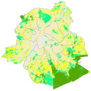
Brussels ecological network
This dataset corresponds to Brussels ecological network, as defined by the nature ordinance of 1 March 2012 and mapped in the Nature Plan. It is made of one geometric classe : the Brussels ccological network, a typology of regional green spaces according to their ecological importance.
Simple
- Date (Publication)
- 2002-01-01
- Date (Revision)
- 2016-01-01
- Identifier
- Bruxelles Environnement / Leefmilieu Brussel / BRU_ENVI_28ec71d7-9685-4594-81f3-d790b8c320e8
- Maintenance and update frequency
- As needed
- GeoBru Administrative Regions
-
- Belgium
- Région de Bruxelles-Capitale
- GeoBru brussels keywords
-
- Bruenvi
- Green Network
- GEMET - INSPIRE themes, version 1.0
-
- Habitats and biotopes
- Access constraints
- Other restrictions
- Other constraints
- No limitations to public access
- Use constraints
- Other restrictions
- Other constraints
- Creative Commons Attribution (CC-BY)
- Spatial representation type
- Vector
- Denominator
- 5000
- Metadata language
- Français
- Topic category
-
- Environment
N
S
E
W
))
- Unique resource identifier
- EPSG:31370
- Distribution format
-
-
GML
()
-
GML
()
- OnLine resource
- OnLine resource
- OnLine resource
- Latest version available (gpkg) ( WWW:DOWNLOAD-1.0-http--download )
- Hierarchy level
- Dataset
Conformance result
- Date (Publication)
- 2010-12-08
- Explanation
- The dataset does not fullfill the minimal requirements
- Pass
- No
- Statement
- Bruxelles Environnement / Leefmilieu Brussel
- File identifier
- d9942976-3e2b-433c-8ebb-86d5afa9aa4c XML
- Metadata language
- Français
- Character set
- MD_CharacterSetCode_utf8
- Hierarchy level
- Dataset
- Date stamp
- 2026-05-19T15:01:53
- Metadata standard name
- ISO19115
- Metadata standard version
- 2003/Cor.1:2006
Overviews
thumbnail

large_thumbnail
Spatial extent
N
S
E
W
Provided by

Associated resources
Not available