 Geobru catalogue
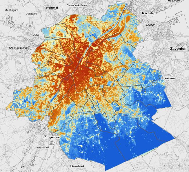
Urban heat islands
This dataset corresponds to urban heat islands. It 's made of a raster image with each pixel corresponding to a standardised Wet Bulb Globe Temperature (WBGT) indicator value from 0 to 100. This indicator measures heat stress based on temperature, humidity, wind, exposure to solar radiation and cloud cover for a typical hot summer day (i.e. 24 August 2016).
Simple
- Date (Publication)
- 2021-03-29
- Date (Revision)
- 2018-12-31
- Date (Creation)
- 2018-12-31
- Identifier
- BE.BELB / BRU_ENVI_73b4f29a-cff0-4d6a-a239-cb99d3140531
- Maintenance and update frequency
- As needed
- GeoBru Administrative Regions
-
- Belgium
- Région de Bruxelles-Capitale
- GEMET - Themes, version 4.2.3
-
- climatic change
- microclimate
- heat wave
- heat stress
- environment
- health
- air temperature
- air
- modelling
- Spatial scope
-
- Regional
- GEMET - INSPIRE themes, version 1.0
-
- Meteorological geographical features
- Access constraints
- Other restrictions
- Other constraints
- No limitations to public access
- Use constraints
- Other restrictions
- Other constraints
- Creative Commons Attribution (CC-BY) - required citation of data source. The full license is available here: https://creativecommons.org/licenses/by/4.0/legalcode
- Spatial representation type
- Grid
- Distance
- 2 m
- Metadata language
- Français
- Topic category
-
- Environment
N
S
E
W
))
- gml32:beginPosition
- 2016-01-01
- gml32:endPosition
- 2016-12-31
- Unique resource identifier
- EPSG:31370
- Distribution format
-
-
GML
()
-
GML
()
- OnLine resource
- OnLine resource
- Urban heat islands ( WWW:LINK-1.0-http--link )
- Hierarchy level
- Dataset
Conformance result
- Date (Publication)
- 2010-12-08
- Explanation
- The dataset does not fullfill the minimal requirements
- Pass
- No
- Statement
-
The study report (in Dutch) is available at http://document.environnement.brussels/opac_css/elecfile/Cartografie_Koelte_Eilanden_BHG
See also the focus on this subject on https://environnement.brussels/lenvironnement-etat-des-lieux/en-detail/climat/cartographie-des-ilots-de-fraicheur-bruxelles
- File identifier
- 73b4f29a-cff0-4d6a-a239-cb99d3140531 XML
- Metadata language
- Français
- Character set
- MD_CharacterSetCode_utf8
- Hierarchy level
- Dataset
- Date stamp
- 2025-12-09T17:24:07
- Metadata standard name
- ISO19115
- Metadata standard version
- 2003/Cor.1:2006
Overviews
thumbnail
large_thumbnail
Spatial extent
N
S
E
W
Provided by

Associated resources
Not available