 Geobru catalogue
INSPIRE - Hydrography
Simple
- Date (Publication)
- 2017-12-22
- Date (Revision)
- 2017-12-22
- Date (Creation)
- 2017-12-22
- Identifier
- BE.BELB / BRU_ENVI_4da44671-0141-4dcd-a03a-87fc00733ba9
- Maintenance and update frequency
- As needed
- GeoBru Administrative Regions
-
- Belgium
- Région de Bruxelles-Capitale
- GeoBru brussels keywords
-
- Blue Network
- Reporting Inspire
- INSPIRE feature concept dictionary
-
- Drainage Basin
- Watercourse Separated Crossing
- Watercourse Link Sequence
- Watercourse Link Sequence
- Standing Water
- Spatial scope
-
- Regional
- Access constraints
- Other restrictions
- Other constraints
- No limitations to public access
- Use constraints
- Other restrictions
- Other constraints
- Creative Commons Attribution (CC-BY) - required citation of data source. The full license is available here: https://creativecommons.org/licenses/by/4.0/legalcode
- Spatial representation type
- Vector
- Denominator
- 500
- Metadata language
- Français
- Topic category
-
- Inland waters
))
- gml32:beginPosition
- 2002-01-01
- gml32:endPosition
- 2020-12-31
- Unique resource identifier
- EPSG:3035
- Distribution format
-
-
GML
()
-
GML
()
- Units of distribution
- MB
- Transfer size
- 0.5
- OnLine resource
-
ms:HY.PhysicalWaters.Catchments
(
WWW:DOWNLOAD-1.0-http--download
)
WFS GetFeature request to the INSPIRE pre-defined dataset of catchment areas - hydrography
- OnLine resource
-
ms:HY.PhysicalWaters.Waterbodies.StandingWater
(
WWW:DOWNLOAD-1.0-http--download
)
WFS GetFeature request to the INSPIRE pre-defined dataset of standing water - hydrography
- OnLine resource
-
HY.Network
(
OGC:WMS
)
View service WMS - Annex I - Hydrography - Watercourse network
- OnLine resource
-
HY.PhysicalWaters.Waterbodies.Watercourse
(
OGC:WMS
)
View service WMS - Annex I - Hydrography - Watercourse
- OnLine resource
-
HY.PhysicalWaters.Waterbodies.StandingWater
(
OGC:WMS
)
View service WMS - Annex I - Hydrography - Standing water
- OnLine resource
-
HY.PhysicalWaters.Catchments
(
OGC:WMS
)
View service WMS - Annex I - Hydrography - Drainage basin
- Hierarchy level
- Dataset
Conformance result
- Date (Publication)
- 2010-12-08
- Explanation
- The dataset does fullfill the minimal requirements
- Pass
- Yes
- Statement
- Bruxelles Environnement / Leefmilieu Brussel
- File identifier
- 4da44671-0141-4dcd-a03a-87fc00733ba9 XML
- Metadata language
- Français
- Hierarchy level
- Dataset
- Date stamp
- 2024-12-19T09:41:55
- Metadata standard name
- ISO19115
- Metadata standard version
- 2003/Cor.1:2006
Overviews
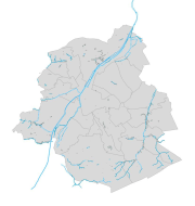

Spatial extent
Provided by
