 Geobru catalogue
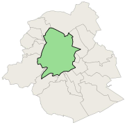
Priority greening zone
This dataset corresponds to the priority greening zone. It is made of one geometric classe : the priority greening zoneas defined in the Regional Plan for Sustainable Development (RPSD).
Simple
- Date (Publication)
- 2002-09-12
- Date (Revision)
- 2016-01-01
- Identifier
- Bruxelles Environnement / Leefmilieu Brussel / BRU_ENVI_074fde59-b35b-492a-9eb6-881672bbbd51
- Maintenance and update frequency
- As needed
- GeoBru Administrative Regions
-
- Belgium
- Région de Bruxelles-Capitale
- GeoBru brussels keywords
-
- Bruenvi
- Green Network
- GEMET - INSPIRE themes, version 1.0
-
- Area management/restriction/regulation zones and reporting units
- Access constraints
- Other restrictions
- Other constraints
- No limitations to public access
- Use constraints
- Other restrictions
- Other constraints
- Creative Commons Attribution (CC-BY)
- Spatial representation type
- Vector
- Denominator
- 10000
- Metadata language
- Français
- Topic category
-
- Environment
N
S
E
W
))
- Unique resource identifier
- EPSG:31370
- Hierarchy level
- Dataset
Conformance result
- Date (Publication)
- 2010-12-08
- Explanation
- The dataset does not fullfill the minimal requirements
- Pass
- No
- Statement
- Bruxelles Environnement / Leefmilieu Brussel
- File identifier
- 074fde59-b35b-492a-9eb6-881672bbbd51 XML
- Metadata language
- Français
- Character set
- MD_CharacterSetCode_utf8
- Hierarchy level
- Dataset
- Date stamp
- 2025-12-09T17:24:07
- Metadata standard name
- ISO19115
- Metadata standard version
- 2003/Cor.1:2006
Overviews
thumbnail

large_thumbnail
Spatial extent
N
S
E
W
Provided by

Associated resources
Not available