 Geobru catalogue
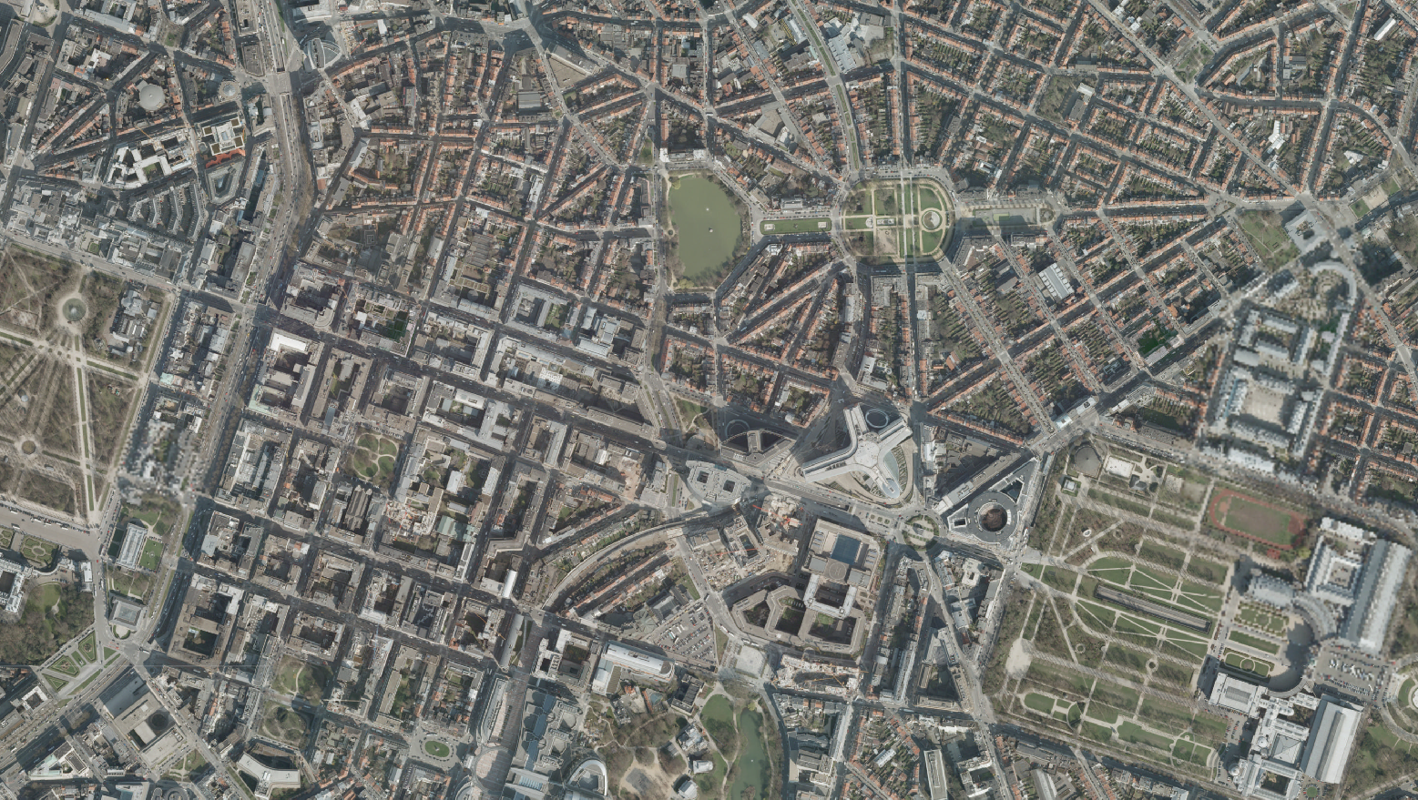
Orthophoto – 2009
Orthofoto - 2009
Orthophoto - 2009
Les orthophotoplans de la Région de Bruxelles-Capitale sont réalisés sur base de photographies aériennes à grande échelle. Cet orthophotoplan couvre l'ensemble du territoire de la région. Les orthophotos disponibles datent de 2009.
De orthofoto van het Brussels Hoofdstedelijk Gewest wordt gemaakt op basis van grootschalige luchtfoto's. Deze orthofoto omvat het hele grondgebied van het Gewest. Orthofoto's beschikbaar van 2009.
The orthophotos of the Brussels-Capital are made on the basis of large-scale aerial photographs. This orthophoto covers the whole territory of the region. Orthophotos available from 2009.
Simple
-
Datum (creatie)Date (Creation)Date (Création)
- 2009-03-31
-
Datum (revisie)Date (Revision)Date (Révision)
- 2016-06-09
-
Datum (publicatie)Date (Publication)Date (Publication)
- 2016-06-09
-
IdentifierIdentifierIdentificateur
- BE.CIRB / BRU_URBIS_ORTHO2009_RBC
contactpunt
Point of contact
Point de contact
Paradigm
Paradigm
Paradigm
https://paradigm.brussels/fr?set_language=fr
-
HerzieningsfrequentieMaintenance and update frequencyFréquence de mise à jour
-
indien nodigAs neededLorsque nécessaire
-
GEMET - INSPIRE themes, version 1.0
-
-
Ortho-imagerieOrthobeeldvormingOrthoimagery
-
-
GeoBru Administrative Regions
-
-
BelgiqueBelgiëBelgium
-
BruxellesBrusselBrussels
-
Région de Bruxelles-CapitaleBrussels Hoofdstedelijk GewestBrussels-Capital Region
-
-
GeoBru brussels keywords
-
-
Fond de planKaartondergrondLayers
-
TopographieTopografieTopography
-
-
Champ géographiqueRuimtelijke dekkingSpatial scope
-
-
RégionalRegionaalRegional
-
-
(Juridische) toegangsrestrictieAccess constraintsContraintes d'accès
-
andersOther restrictionsAutres restrictions
-
Autres contraintesOverige beperkingenOther constraints
-
Pas de restriction concernant l'accès publicGeen beperkingen op openbare toegangNo limitations to public access
-
(Juridische) gebruiksbeperkingUse constraintsContraintes d'utilisation
-
andersOther restrictionsAutres restrictions
-
Ruimtelijk schemaSpatial representation typeType de représentation spatiale
-
gridGridRaster
-
AfstandDistanceDistance de résolution
- 60 cm
-
TaalMetadata languageLangue
- Français
-
TaalMetadata languageLangue
- Nederlands; Vlaams
-
OnderwerpTopic categoryCatégorie ISO
-
-
referentie materiaal aardbedekkingImagery base maps earth coverImagerie/Cartes de base/Occupation des terres
-
N
S
E
W
))
- gml32:beginPosition
- 2009-03-31T00:00:00
- gml32:endPosition
- 2009-03-31T00:00:00
-
CodeCodeUnique resource identifier
-
EPSG:31370EPSG:31370EPSG:31370
-
Geometrisch objecttypeGeometric object typeType de géométries des objets
-
complexComplexComplexe
-
Aantal geometrische objectenGeometric object countNombre d'objets géométriques
- 1
-
Distributie formaatDistribution formatFormat (encodage)
-
-
MrSID( - )
-
-
OnLine bronnenOnLine resourceRessource en ligne
-
View service – Raster
(
OGC:WMS
)
View service – Raster
-
OnLine bronnenOnLine resourceRessource en ligne
-
Niveau kwaliteitsbeschrijvingHierarchy levelNiveau
-
seriesSeriesCollection de données
Resultaat conformiteit met de specificatie
Conformance result
Résultat de conformité
-
Datum (publicatie)Date (Publication)Date (Publication)
- 2010-12-08
-
ExplicationUitlegExplanation
-
Le jeu de données répond aux exigences minimales prédécritesDe dataset volgt de minimale vereissenThe dataset does fullfill the minimal requirements
-
Indicatie van conformiteit met de specificatiePassDegré de conformité
- Yes
-
Généralités sur la provenance
-
Les orthophotoplans sont construits sur base de photographies aériennes à grande échelle.
-
Metadata IDFile identifierIdentifiant de la fiche
- 79f32a11-1bad-4dd1-a691-be10033d1f09 XML
-
TaalMetadata languageLangue
- Français
-
Hierarchisch niveauHierarchy levelType de ressource
-
datasetDatasetJeu de données
-
Metadata datumDate stampDate des métadonnées
- 2024-03-26T15:09:02
contactpunt
Point of contact
Point de contact
Paradigm
Paradigm
Paradigm
https://paradigm.brussels/fr?set_language=fr
Overviews
Spatial extent
N
S
E
W
Provided by

Associated resources
Not available