 Geobru catalogue
Brusky - Ortho 1930-1935
Bruciel – Ortho 1930-1935
Brulucht - Ortho 1930-1935
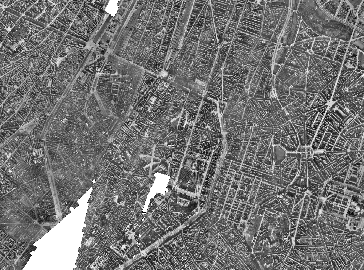
The Brusky Ortho 1930-1935 product is a set of gray scale (black and white) orthophotomaps covering apart of the current territory of the Brussels Region. The images used for these orthophotoplans were taken between 1930 and 1935.
Le produit Bruciel Ortho 1930-1935 regroupe un ensemble d'orthophotoplans en niveaux de gris (noir et blanc) couvrant une partie du territoire actuel de la Région bruxelloise. Les images utilisées pour ces orthophotoplans ont été prises en 1930 et en 1935.
Het product Brulucht Ortho 1930-1935 is een verzameling grijsschaal (zwart en wit) orthofotoplannen die een deel van het huidige grondgebied van het Brusselse Gewest bestrijkt. De beelden die gebruikt zijn voor deze orthofotoplannen zijn gemaakt tussen 1930 en 1935.
Simple
-
Date (Création)Datum (creatie)Date (Creation)
- 2022-12-01
-
Date (Révision)Datum (revisie)Date (Revision)
- 2022-12-01
-
IdentificateurIdentifierIdentifier
- BE.BRUSSELS.URBAN / 645cac17-d265-11ee-a34f-40ec994184cf
-
EtatStatusStatus
-
FinalisécompleetCompleted
Gestionnaire
beheerder
Custodian
Brussels Regional Public Service Urbanism and Heritage
Service public régional Bruxelles Urbanisme et Patrimoine
Gewestelijke Overheidsdienst Brussel Stedenbouw en Erfgoed
https://urban.brussels/en
-
Fréquence de mise à jourHerzieningsfrequentieMaintenance and update frequency
-
Non planifiéeniet geplandNot planned
-
Contraintes d'accès(Juridische) toegangsrestrictieAccess constraints
-
Autres restrictionsandersOther restrictions
-
Other constraintsAutres contraintesOverige beperkingen
-
public access limited according because of existing intellectual rightsAccès public restreint à cause de droits intellectuels existantsDe publieke toegang is beperkt om geen afbreuk te doen aan intellectuele-eigendomsrechten
-
Contraintes d'utilisation(Juridische) gebruiksbeperkingUse constraints
-
Autres restrictionsandersOther restrictions
-
Type de représentation spatialeRuimtelijk schemaSpatial representation type
-
RastergridGrid
-
Distance de résolutionAfstandDistance
- 10 m
-
LangueTaalMetadata language
- Nederlands; Vlaams
-
LangueTaalMetadata language
- Français
-
Jeu de caractèresKaraktersetCharacter set
-
Utf8utf8UTF8
-
Catégorie ISOOnderwerpTopic category
-
-
Imagerie/Cartes de base/Occupation des terresreferentie materiaal aardbedekkingImagery base maps earth cover
-
-
DescriptionDescriptionOmschrijving
-
Brussels-Capital RegionRégion de Bruxelles-CapitaleBrussel Hoofstedelijk Gewest
N
S
E
W
))
-
Unique resource identifierCodeCode
-
EPSG:31370EPSG:31370EPSG:31370
- Codespace
- EPSG
-
Format (encodage)Distributie formaatDistribution format
-
NiveauNiveau kwaliteitsbeschrijvingHierarchy level
-
Jeu de donnéesdatasetDataset
-
StatementGénéralités sur la provenanceAlgemene beschrijving herkomst
-
This dataset is based on flights taken in 1930 and 1935 for the Belgian Ministry of Public Works (Topography and Photogrammetry Service). The photographs from 1930 are held in the form of positives and/or negatives in the urban.brussels collections. For 1935, some are held in the Flemish Government Archives, at the Department of Mobility and Public Works, General Technical Support. The 1930 flight took place on 1 December on a North-North-East / South-South-West axis, at an undetermined altitude. The 1935 flights took place on 15 and 19 February on a North-North-East / South-South-West route, also at an undetermined altitude.Ce jeu de données est produit à partir de vols réalisés en 1930 et 1935 pour le Ministère des Travaux publics de l'État belge (Service de Topographie et de Photogrammétrie). Les photos sont conservées sous forme de positifs et/ou de négatifs dans les collections d'urban.brussels pour l'ensemble des photos de 1930. Pour 1935, une partie est conservée dans les Archives du Gouvernement Flamand, au Département de la Mobilité et des Travaux Publics, Support Technique Général. Le vol de 1930 a eu lieu le 1er décembre sur un axe Nord Nord Est / Sud Sud Ouest, à une altitude indéterminée. Les vols de 1935 ont eu lieu les 15 et 19 février sur un axe Nord Nord Est / Sud Sud Ouest, également à une altitude indéterminée.Deze dataset is gebaseerd op vluchten die in 1930 en 1935 zijn gemaakt voor het Belgische Ministerie van Openbare Werken (Dienst Topografie en Fotogrammetrie). De foto's van 1930 worden in de vorm van positieven en/of negatieven bewaard in de collecties urban.brussels. Voor 1935 worden sommige foto's bewaard in het Archief van de Vlaamse Overheid, bij het Departement Mobiliteit en Openbare Werken, Algemene Technische Ondersteuning. De vlucht van 1930 vond plaats op 1 december op een Noord-Noord-Oost / Zuid-Zuid-West as, op een onbepaalde hoogte. De vluchten van 1935 vonden plaats op 15 en 19 februari op een Noord-Noord-Oost / Zuid-Zuid-West route, ook op een onbepaalde hoogte.
-
Identifiant de la ficheMetadata IDFile identifier
- 64591fd2-d265-11ee-ba69-40ec994184cf XML
-
LangueTaalMetadata language
- English
-
Jeu de caractèresKaraktersetCharacter set
-
Utf8utf8UTF8
-
Type de ressourceHierarchisch niveauHierarchy level
-
Jeu de donnéesdatasetDataset
-
Date des métadonnéesMetadata datumDate stamp
- 2026-06-18T10:06:21
- Metadata standard name
- Brussels INSPIRE metadata profil
Point de contact
contactpunt
Point of contact
Paradigm
Paradigm
Paradigm
Place Saint-Lazare, 2
Place Saint-Lazare, 2
Sint-Lazarusplein, 2
,
Saint-Josse-ten-Noode
,
1210
,
Belgium
Belgique
Belgïe
Overviews
Spatial extent
N
S
E
W
Provided by

Associated resources
Not available