 Geobru catalogue
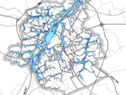
Aléa d'inondation 2019
Overstromingsgevaar 2019
Flood hazard 2019
Région de Bruxelles-Capitale : Cette carte d’aléa d’inondation repère les zones où pourraient se produire des inondations suite au débordement de cours d'eau, au ruissellement, au refoulement d'égouts ou à la remontée temporaire de la nappe phréatique, même aux endroits où aucune inondation n’a été recensée jusqu’à présent. L'absence d'une zone d'aléa sur la carte ne peut garantir qu'une inondation ne s'y produira jamais, car certaines causes d’inondation ne sont pas prises en compte comme un défaut local du réseau d’écoulement,... Attention, ces cartes n’ont aucune valeur réglementaire, elles ont été produites conformément à la directive européenne 2007/60/CE visant à déterminer les actions de prévention et de protection. L’échelle max. est 1/10.000, vu la non représentativité des données modélisées à une plus grande échelle.
Brussels Hoofdstedelijk Gewest : Deze overstromingsgevaarkaart geeft de zones weer waar overstromingen zouden kunnen voordoen door overstroomde waterlopen, afstomend regenwater, overlopende riolen of een tijdelijke stijging van de grondwaterspiegel, zelfs op plaatsen waar tot nu toe geen overstroming werd waargenomen. De afwezigheid van een gevaarzone op de kaart garandeert niet dat er nooit een overstroming zal plaatsvinden want er wordt geen rekening gehouden met bepaalde overstromingsoorzaken zoals een lokaal defect aan het rioolnetwerk,... Opgepast, deze kaarten hebben geen enkele reglementaire waarde, ze zijn opgesteld volgens de Europese richtlijn 2007/60/EG om voorzorgs- en beschermingsmaatregelen te bepalen. De max. schaal is 1/10.000 gezien de niet representativiteit van de gemodelleerde gegevens op grotere schaal.
Brussels-Capital Region : This flood hazard map identifies areas where flooding could occur due to stream overflow, runoff from rainwater, overflowing sewers or a temporary rise in the water table, even in places where no flooding has been observed until now. The absence of a flood hazard zone on the map does not guarantee that flooding will never occur as it does not take into account certain causes of flooding such as a local failure of the sewage network, etc. Please note that these maps have no regulatory value, they have been produced in accordance with the European Directive 2007/60/EC to determine the prevention and protection measures. The maximum scale is 1/10.000 as the modelled data are not representative on a larger scale.
Simple
-
Datum (publicatie)Date (Publication)Date (Publication)
- 2020-03-22
-
Datum (revisie)Date (Revision)Date (Révision)
- 2020-03-22
-
Datum (creatie)Date (Creation)Date (Création)
- 2020-03-22
-
IdentifierIdentifierIdentificateur
- Bruxelles Environnement / Leefmilieu Brussel / BRU_ENVI_2f75f24b-961a-45f1-a2ca-0eed6b55d812
contactpunt
Point of contact
Point de contact
Bruxelles Environnement
Leefmilieu Brussel
Brussels Environment
Avenue du Port 86C bte 3000
Havenlaan 86C bus 3000
Avenue du Port 86C box 3000
,
Bruxelles
,
1000
,
Belgique
België
Belgium
contactpunt
Point of contact
Point de contact
Bruxelles Environnement
Leefmilieu Brussel
Brussels Environment
Avenue du Port 86C bte 3000
Havenlaan 86C bus 3000
Avenue du Port 86C box 3000
,
Bruxelles
,
1000
,
Belgique
België
Belgium
-
HerzieningsfrequentieMaintenance and update frequencyFréquence de mise à jour
-
indien nodigAs neededLorsque nécessaire
-
GeoBru Administrative Regions
-
-
BelgiqueBelgiëBelgium
-
Région de Bruxelles-CapitaleBrussels Hoofdstedelijk GewestRégion de Bruxelles-Capitale
-
-
Champ géographiqueRuimtelijke dekkingSpatial scope
-
-
RégionalRegionaalRegional
-
-
(Juridische) toegangsrestrictieAccess constraintsContraintes d'accès
-
andersOther restrictionsAutres restrictions
-
Autres contraintesOverige beperkingenOther constraints
-
Pas de restriction concernant l'accès publicGeen beperkingen op openbare toegangNo limitations to public access
-
(Juridische) gebruiksbeperkingUse constraintsContraintes d'utilisation
-
andersOther restrictionsAutres restrictions
-
Ruimtelijk schemaSpatial representation typeType de représentation spatiale
-
gridGridRaster
-
ToepassingsschaalDenominatorDénominateur de l'échelle
- 10000
-
TaalMetadata languageLangue
- Français
-
TaalMetadata languageLangue
- Nederlands; Vlaams
-
OnderwerpTopic categoryCatégorie ISO
-
-
natuur en milieuEnvironmentEnvironnement
-
N
S
E
W
))
- gml32:beginPosition
- 2013-01-01
- gml32:endPosition
- 2013-12-31
-
CodeCodeUnique resource identifier
-
EPSG:31370EPSG:31370EPSG:31370
-
Distributie formaatDistribution formatFormat (encodage)
-
-
GMLGMLGML()
-
-
OnLine bronnenOnLine resourceRessource en ligne
- Cartes d'aléa d'inondation pour la Région bruxelloise Overstromingskaarten voor het Brussels Gewest Flood hazard mapping for the Brussels Region ( WWW:LINK-1.0-http--link )
-
OnLine bronnenOnLine resourceRessource en ligne
-
OnLine bronnenOnLine resourceRessource en ligne
-
OnLine bronnenOnLine resourceRessource en ligne
- https://ows.environnement.brussels/water/wfs3/api ( OGC API-Features )
-
Niveau kwaliteitsbeschrijvingHierarchy levelNiveau
-
datasetDatasetJeu de données
Resultaat conformiteit met de specificatie
Conformance result
Résultat de conformité
-
Datum (publicatie)Date (Publication)Date (Publication)
- 2010-12-08
-
ExplicationUitlegExplanation
-
Le jeu de données ne répond pas aux exigences minimales prédécritesDe dataset volgt niet de minimale vereissenThe dataset does not fullfill the minimal requirements
-
Indicatie van conformiteit met de specificatiePassDegré de conformité
- No
-
Généralités sur la provenance
-
Bruxelles Environnement / Leefmilieu Brussel
-
Metadata IDFile identifierIdentifiant de la fiche
- 2f75f24b-961a-45f1-a2ca-0eed6b55d812 XML
-
TaalMetadata languageLangue
- Français
-
KaraktersetCharacter setJeu de caractères
-
MD_CharacterSetCode_utf8MD_CharacterSetCode_utf8MD_CharacterSetCode_utf8
-
Hierarchisch niveauHierarchy levelType de ressource
-
datasetDatasetJeu de données
-
Metadata datumDate stampDate des métadonnées
- 2025-12-09T17:24:07
- Metadata standard name
- ISO19115
- Metadata standard version
- 2003/Cor.1:2006
contactpunt
Point of contact
Point de contact
Bruxelles Environnement
Leefmilieu Brussel
Brussels Environment
Avenue du Port 86C bte 3000
Havenlaan 86C bus 3000
Avenue du Port 86C box 3000
,
Bruxelles
,
1000
,
Belgique
België
Belgium
Overviews
thumbnail

large_thumbnail
Spatial extent
N
S
E
W
Provided by

Associated resources
Not available