 Geobru catalogue
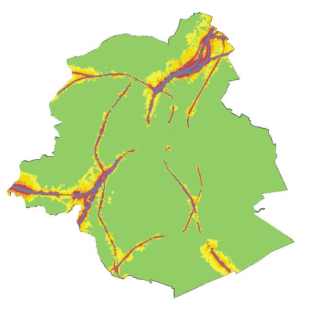
Strategic noise maps
This dataset corresponds to the noise indicators in the Brussels-Capital Region, in accordance with the requirements of European Directive 2002/49/EC. It comprises 16 geometric classes, broken down according to noise source (air, rail, road or multi-exposure), acoustic indicator (Lden and Ln) and reference year (2016 and 2021).
Simple
- Date (Creation)
- 2024-04-30
- Date (Revision)
- 2024-04-30
- Identifier
- BE.BELB / 2e0538f9-f7f4-4210-b645-08c9f7c732cb
- Status
- Completed
- Maintenance and update frequency
- As needed
- GeoBru Administrative Regions
-
- Belgium
- Région de Bruxelles-Capitale
- GEMET - INSPIRE themes, version 1.0
-
- Human health and safety
- Access constraints
- Other restrictions
- Other constraints
- No limitations to public access
- Use constraints
- Other restrictions
- Other constraints
- Creative Commons Attribution (CC-BY)
- Spatial representation type
- Vector
- Distance
- 10 m
- Metadata language
- Français
- Metadata language
- Nederlands; Vlaams
- Metadata language
- English
- Topic category
-
- Environment
N
S
E
W
))
- gml32:beginPosition
- 2016-01-01
- gml32:endPosition
- 2016-12-31
- Unique resource identifier
- EPSG:31370
- Hierarchy level
- Dataset
Conformance result
- Date (Publication)
- 2010-12-08
- Explanation
- The dataset does not fullfill the minimal requirements
- Pass
- No
- Statement
- The contour maps are based on acoustic models in accordance with the recommendations of European Directive 2002/49/EC. For air traffic noise, modelling was carried out using CadnaA software (version 2018), based on the 1997 European Civil Aviation Conference (ECAC) method. For rail noise, modelling was carried out using IMMI software (version 6.2), based on the 1996 Standaard Reken Methode II (SRMII) (Dutch national calculation method). For road noise, modelling was based on the NMPB-Routes-96 metode (NMPB).
- File identifier
- 2e0538f9-f7f4-4210-b645-08c9f7c732cb XML
- Metadata language
- Français
- Character set
- MD_CharacterSetCode_utf8
- Hierarchy level
- Dataset
- Date stamp
- 2025-12-09T17:24:07
- Metadata standard name
- ISO19115
- Metadata standard version
- 2003/Cor.1:2006
Overviews

thumbnail
large_thumbnail
Spatial extent
N
S
E
W
Provided by

Associated resources
Not available