 Geobru catalogue
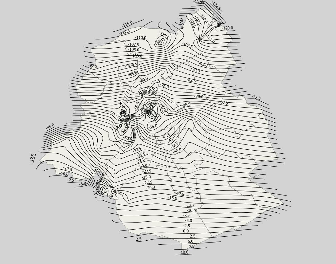
Elevation of the tops of the Stratigraphic Units of the Brussels-Capital Region (SU/BCR)
Brussels-Capital Region: elevation of the tops of the Stratigraphic Units of the Brussels-Capital Region (SU/BCR), excluding quaternary units. Elevations (m-DNG/TAW) are represented by contour lines spaced with a 2.5m pitch. Data is limited to the Brussels-Capital Region’s border extended with a 500 m buffer zone. These elevations were extracted from the BruStrati3D v1.1 geological model.
This data is generated from models and may contain errors, inaccuracies and gaps. It has informative value and may under no circumstances replace a study carried out by an expert. Bruxelles Environnement cannot be held liable for the consequences of the use of this information.
Simple
- Date (Publication)
- 2019-03-07
- Date (Revision)
- 2019-03-07
- Date (Creation)
- 2019-03-07
- Identifier
- BE.BELB / BRU_ENVI_820bf261-1e1a-43a2-abfd-451d353e88f1
- Maintenance and update frequency
- As needed
- GeoBru Administrative Regions
-
- Belgium
- Région de Bruxelles-Capitale
- Access constraints
- Other restrictions
- Other constraints
- No limitations to public access
- Use constraints
- Other restrictions
- Other constraints
- Creative Commons Attribution (CC-BY) - required citation of data source. The full license is available here: https://creativecommons.org/licenses/by/4.0/legalcode
- Spatial representation type
- Vector
- Denominator
- 500
- Metadata language
- Français
- Topic category
-
- Geoscientific information
))
- gml32:beginPosition
- 2019-03-07
- gml32:endPosition
- 2024-01-01
- Unique resource identifier
- EPSG:31370
- Distribution format
-
-
GML
()
-
GML
()
- Units of distribution
- B
- Transfer size
- 1
- OnLine resource
- geology_stratigraphy_top ( WWW:DOWNLOAD-1.0-http--download )
- Hierarchy level
- Dataset
Conformance result
- Date (Publication)
- 2010-12-08
- Explanation
- The dataset does not fullfill the minimal requirements
- Pass
- No
- Statement
- Bruxelles Environnement / Leefmilieu Brussel
- File identifier
- 70e59294-5de7-46e8-8271-207417f48a8e XML
- Metadata language
- Français
- Character set
- MD_CharacterSetCode_utf8
- Hierarchy level
- Dataset
- Date stamp
- 2024-03-08T12:49:00
- Metadata standard name
- ISO19115
- Metadata standard version
- 2003/Cor.1:2006
Overviews

Spatial extent
Provided by
