• Geobru catalogue
  •  
  •  
  •  

INSPIRE - Nitrate-vulnerable zone

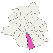
Brussels-Capital Region: The nitrate-vulnerable zone is a protected area against the pollution of groundwaters caused by nitrates from agricultural sources. It was designated in accordance with the prescriptions of the European Directive 91/676/EEC, by the Ministerial Order of 25 May 1999.

Simple

Date (Revision)
2018-04-30
Date (Publication)
2018-04-30
Date (Creation)
2007-09-17
Identifier
BE.BELB / BRU_ENVI_5c3a9125-5225-462a-8914-f63d8ed8d859
Status
Completed
Point of contact
  Brussels Environment
Avenue du Port 86C box 3000 , Bruxelles , 1000 , Belgium
https://environnement.brussels/
GEMET - INSPIRE themes, version 1.0
  • Area management/restriction/regulation zones and reporting units
INSPIRE feature concept dictionary
  • Management Restriction Or Regulation Zone
High-value dataset categories
  • Geospatial
Spatial scope
  • Regional
GeoBru Administrative Regions
  • Belgium
  • Région de Bruxelles-Capitale
GEMET - Themes, version 4.2.3
  • pollution
  • groundwater pollution
  • environmental impact of agriculture
  • nitrate
  • groundwater
  • groundwater protection
  • water (substance)
  • water protection legislation
  • groundwater quality
GeoBru brussels keywords
  • Reporting Inspire
INSPIRE priority data set
  • Protected areas (Water Framework Directive)
  • Nitrate vulnerable zones - nutrient sensitive areas (Water Framework Directive)
  • Directive 2000/60/EC
Access constraints
Other restrictions
Other constraints
No limitations to public access
Use constraints
Other restrictions
Other constraints
Creative Commons Attribution (CC-BY) - required citation of data source. The full license is available here: https://creativecommons.org/licenses/by/4.0/legalcode
Spatial representation type
Vector
Metadata language
English
Topic category
  • Environment
N
S
E
W
thumbnail


Unique resource identifier
EPSG:3035
Distribution format
  • GML ()

Units of distribution
B
Transfer size
1
OnLine resource
  • INSPIRE - Download service ATOM/Opensearch - Annex III.11 - Area management/restriction/regulation zones and reporting units
OnLine resource
  • INSPIRE - View service - Area management/restriction/regulation zones and reporting units
Hierarchy level
Dataset

Conformance result

Date (Publication)
2010-12-08
Explanation
The dataset does fullfill the minimal requirements
Pass
Yes
Statement
Bruxelles Environnement / Leefmilieu Brussel
File identifier
5c3a9125-5225-462a-8914-f63d8ed8d859 XML
Metadata language
Français
Hierarchy level
Dataset
Hierarchy level name
dataset
Date stamp
2025-06-25T12:07:34
Metadata standard name
INSPIRE Metadata Implementing Rules
Metadata standard version
Technical Guidelines for implementing dataset and service metadata based on ISO/TS 19139:2007 (Version 2.0.1)
Point of contact
  Brussels Environment
Avenue du Port 86C box 3000 , Bruxelles , 1000 , Belgium
https://environnement.brussels/


Overviews

overview
thumbnail
overview
large_thumbnail

Spatial extent

N
S
E
W
thumbnail


Keywords

GEMET - INSPIRE themes, version 1.0
Area management/restriction/regulation zones and reporting units
GEMET - Themes, version 4.2.3
environmental impact of agriculture groundwater groundwater pollution groundwater protection groundwater quality nitrate pollution water (substance) water protection legislation
GeoBru brussels keywords
Reporting Inspire
INSPIRE feature concept dictionary
Management Restriction Or Regulation Zone
INSPIRE priority data set
Directive 2000/60/EC Nitrate vulnerable zones - nutrient sensitive areas (Water Framework Directive) Protected areas (Water Framework Directive)
Spatial scope
Regional

Provided by

logo

Share on social sites

Access to the portal
Read here the full details and access to the data.

Associated resources

Not available


  •  
  •  
  •